Hurricane Beryl, the first named storm of the 2024 Atlantic hurricane season, has been closely monitored by meteorologists and weather enthusiasts alike. As it continues its path across the Atlantic, various tracking models and weather updates are providing needed information about its trajectory and potential impact.
Current Status and Path
As of the latest updates, Hurricane Beryl is classified as a Category 1 storm with sustained winds reaching up to 85 mph. The National Hurricane Center (NHC) has issued advisories indicating that Beryl is moving west-northwest at a speed of 15 mph. The storm is currently positioned approximately 600 miles east of Barbados and is expected to impact the Windward Islands within the next 48 hours.
Tracking and Projections
Weather agencies, including the NOAA and the NHC, are utilizing advanced tracking systems and spaghetti models to predict Beryl’s path. Spaghetti models, which show a variety of possible trajectories based on different forecast models, suggest that Beryl could potentially affect regions including Barbados, Grenada, and the Windward Islands. These projections help local authorities and residents prepare for possible landfall scenarios.
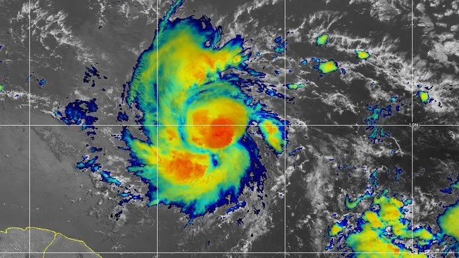
Mike’s Weather Page, a popular resource for storm tracking, has been providing regular updates and insights into Beryl’s development. The page’s analysis includes the latest satellite imagery, wind speed data, and pressure readings, contributing to a comprehensive understanding of the storm’s behavior.
Impact on Barbados and Surrounding Areas
Barbados, which lies directly in the projected path of Beryl, is under a hurricane warning. Residents have been advised to secure their homes and prepare for potential power outages and flooding. Local authorities have set up emergency shelters and are coordinating with disaster response teams to ensure the safety of the population.
The Windward Islands, including Grenada, are also on high alert. These regions, known for their susceptibility to hurricanes, have begun implementing precautionary measures. Emergency services are on standby, and evacuation plans are in place for areas most at risk.
Tropical Storm Beryl’s Evolution
Initially forming as a tropical storm, Beryl rapidly intensified into a hurricane over the past few days. This rapid intensification has been attributed to favorable sea surface temperatures and low wind shear conditions in the Atlantic. Meteorologists from Tropical Tidbits have noted that such conditions are conducive to further strengthening, although fluctuations in intensity are possible as the storm approaches land.
Preparing for Beryl’s Arrival
Local weather services and authorities in the affected regions are urging residents to stay informed through official channels. The NOAA Hurricane Tracker and other weather pages are providing real-time updates on Beryl’s status, helping communities to make informed decisions.
Emergency kits, including non-perishable food, water, medical supplies, and flashlights, are being recommended for all residents in the storm’s path. Additionally, securing property and adhering to evacuation orders, if issued, are critical steps in ensuring personal safety.
As Hurricane Beryl continues its journey across the Atlantic, the focus remains on preparedness and accurate information dissemination. With advanced tracking tools and coordinated efforts from weather agencies and local authorities, the goal is to minimize the impact and safeguard lives and property.
For ongoing updates, residents and interested parties are encouraged to follow official sources such as the NHC, NOAA, and trusted weather pages like Mike’s Weather Page. The coming days will be crucial in determining Beryl’s impact, and staying informed is the best defense against this formidable natural event.